


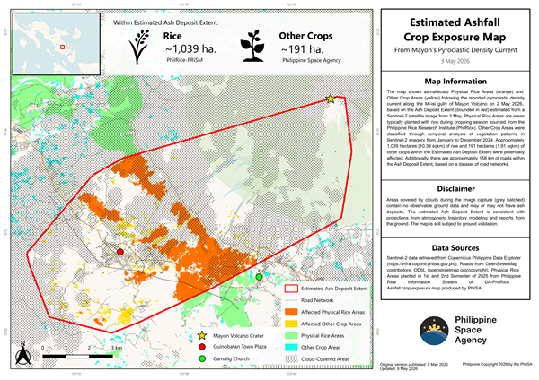
Philippine Space Agency (PhilSA) has released a satellite-based crop exposure map identifying agricultural areas potentially affected by ash deposits following the reported pyroclastic density current along the Mi-isi gully of Mayon Volcano on May 2, 2026.
Using satellite imagery and geospatial analysis, PhilSA estimated that at least 1,039 hectares of Physical Rice Areas and 191 hectares of Other Crop Areas fall within the agency’s Estimated Ash Deposit Extent. The total potentially affected agricultural land covers around 1,230 hectares—roughly equivalent to the size of Mandaluyong City.
The analysis combined crop datasets from the Philippine Rice Research Institute and vegetation monitoring using Sentinel-2 satellite imagery captured throughout 2024. PhilSA also identified at least 158 kilometers of roads located within the ash-affected zone.
According to PhilSA, cloud cover remains a challenge in satellite-based monitoring, as some areas obscured during image capture may still contain ash deposits. Despite these limitations, the estimated ash extent aligns with atmospheric trajectory models and ground reports, although validation on-site is still ongoing.
The agency said the use of satellite data provides wide-area situational awareness that supports the National Disaster Risk Reduction and Management Council (NDRRMC) in prioritizing response operations and monitoring affected communities.
PhilSA emphasized that accessible space data can improve disaster preparedness, response coordination, and decision-making among government agencies and stakeholders. The agency will continue monitoring satellite imagery as volcanic activity develops.