Tag: Sentinel-2 imagery

News

PhilSA Satellite Analysis Reveals Over 1,200 Hectares of Crops Potentially Affected by Mayon Ashfall

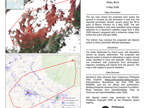
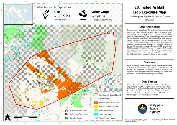
Philippine Space Agency (PhilSA) has released a satellite-based crop exposure map identifying agricultural areas potentially affected by ash deposits following the reported pyroclastic density current along the Mi-isi gully of Mayon Volcano on May 2, 2026. Using satellite imagery and geospatial analysis, PhilSA estimated that at least 1,039 hectares of Physical Rice Areas and 191 […]

Industry Verticals News

PhilSA Satellite Mapping Reveals 8,544-Hectare Ashfall Zone from Mayon Volcano Pyroclastic Event

The Philippine Space Agency has released a satellite-based map identifying extensive ash deposits following a pyroclastic density current along the Mi-isi gully of Mayon Volcano on May 2, 2026. Using change detection analysis from European Space Agency’s Sentinel-2 satellite imagery, PhilSA compared data from May 4, 2026 with a reference image taken on April 28, […]

Email Us

For inquiries, press releases, and partnership request, get in touch with us at: info.aitimes.ph@gmail.com.

Contact: 0956-344-3286

AI Times  @2026. All Rights Reserved.