


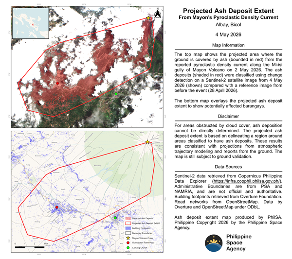
The Philippine Space Agency has released a satellite-based map identifying extensive ash deposits following a pyroclastic density current along the Mi-isi gully of Mayon Volcano on May 2, 2026.
Using change detection analysis from European Space Agency’s Sentinel-2 satellite imagery, PhilSA compared data from May 4, 2026 with a reference image taken on April 28, 2026 to determine affected areas. The analysis identified ash deposits covering approximately 8,544 hectares, or around 85 square kilometers—roughly half the size of Quezon City.
The satellite-derived map shows ashfall zones marked in red, with estimated coverage extending across multiple barangays. While cloud cover limited visibility in some areas, PhilSA was able to extrapolate deposit boundaries using spatial modeling techniques, supported by atmospheric trajectory data and ground reports. The findings remain subject to field validation.
According to PhilSA, satellite data plays a critical role in disaster monitoring by providing wide-area coverage that supports the National Disaster Risk Reduction and Management Council (NDRRMC) in identifying priority areas for response and relief operations. The agency emphasized that space-based data enhances situational awareness during volcanic events, particularly when ground access is limited.
PhilSA continues to monitor satellite imagery as volcanic activity and environmental conditions evolve. Authorities have urged the public to follow official advisories from local and national disaster agencies for the latest updates.
The agency has made the high-resolution ashfall map and geospatial data publicly available to support researchers, responders, and stakeholders involved in disaster risk management.