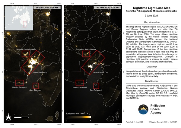


The Philippine Space Agency is leveraging satellite imagery to help assess the impact of the magnitude 7.8 earthquake that struck Mindanao on June 8, using changes in nighttime lights as an early indicator of damage and disruption in affected communities.
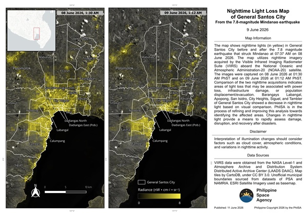
By comparing satellite images captured before and after the earthquake, PhilSA identified areas showing significant reductions in nighttime illumination, which can indicate power outages, infrastructure damage, or population displacement. The analysis provides disaster response agencies with a rapid overview of potentially affected locations while ground assessments continue.
Preliminary findings highlighted decreased nighttime light levels in several barangays in General Santos City, including Labangal, Apopong, San Isidro, City Heights, Siguel, and Tambler. Similar patterns were observed in the municipalities of Maasim and Glan, as well as Polomolok, suggesting these areas may have experienced substantial impacts from the earthquake.
PhilSA noted that the analysis remains preliminary and is being refined to improve the identification of affected locations. The agency also plans to use the return of nighttime lights as a proxy for tracking reconstruction and recovery efforts in the coming weeks and months.
The satellite-based assessment supports the National Disaster Risk Reduction and Management Council by providing wide-area situational awareness that can help prioritize response operations and resource allocation. The use of space-based data enables authorities to quickly identify areas that may require urgent assistance, particularly when access on the ground is limited.
The earthquake, centered off Sarangani, caused widespread damage across parts of Mindanao and was followed by thousands of aftershocks, prompting ongoing monitoring and recovery efforts by national and local agencies.