


The Philippine Space Agency (PhilSA) is leveraging satellite technology to assess the impact of the magnitude 7.8 earthquake that struck southern Mindanao on June 8, 2026, providing critical data to support disaster response efforts.
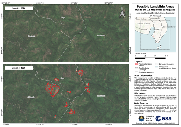
Using imagery captured by the European Space Agency’s Sentinel-2A and Sentinel-2B satellites, PhilSA identified potential earthquake-induced landslides across Glan, Sarangani, and Jose Abad Santos, Davao Occidental. Initial analysis estimates that about 137.87 hectares, or roughly 1.38 square kilometers, may have been affected.
The agency detected landslide-prone areas by comparing pre-disaster images taken on June 1 with post-disaster images captured on June 14. Through Normalized Difference Vegetation Index (NDVI) analysis, PhilSA measured significant vegetation loss, allowing analysts to identify exposed soil that may indicate landslides. The findings remain subject to ground validation.
The satellite-generated maps provide wide-area situational awareness for the National Disaster Risk Reduction and Management Council (NDRRMC), helping authorities prioritize emergency response and resource deployment in affected communities.
PhilSA said it will continue monitoring satellite data as conditions evolve, reinforcing the role of space technology in enhancing disaster risk reduction, emergency response, and informed decision-making across the country.