







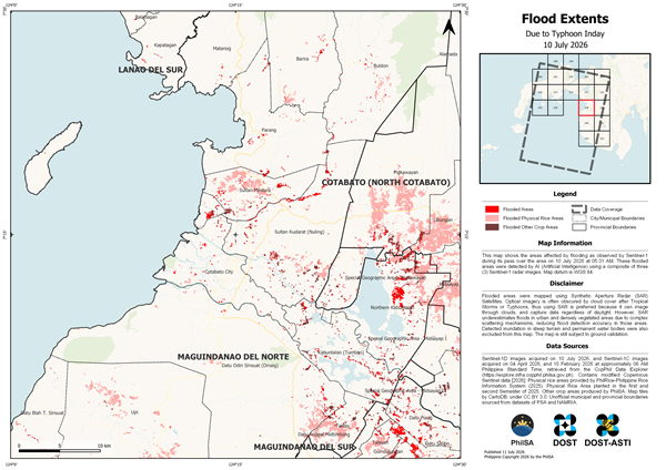
The Philippine Space Agency (PhilSA) has released artificial intelligence (AI)-assisted flood extent maps to help government agencies assess flooding caused by the enhanced southwest monsoon triggered by Typhoon Inday.
Using Sentinel-1 Synthetic Aperture Radar (SAR) satellite imagery captured on July 10 and 11, 2026, PhilSA identified flooded areas across Regions 9, 10, 11, 12, 13, the Bangsamoro Autonomous Region in Muslim Mindanao (BARMM), and parts of Eastern Samar and Southern Leyte. AI was used to analyze a composite of three SAR satellite images, enabling faster detection of flood-affected areas, including physical rice areas and other agricultural lands.
Unlike optical satellites, SAR technology can capture images through cloud cover and in both day and night conditions, making it particularly effective for disaster monitoring during severe weather. PhilSA noted, however, that SAR imagery may underestimate flooding in urban and densely vegetated areas because of complex surface conditions that affect radar backscatter. The agency added that the flood maps remain subject to ground validation.
The AI-assisted satellite analysis supports the National Disaster Risk Reduction and Management Council (NDRRMC) in monitoring the situation, prioritizing response efforts, and improving decision-making through timely access to space-based data.
PhilSA said it will continue monitoring satellite imagery as weather conditions evolve and encouraged the public to follow official government advisories for the latest updates. Flood extent maps and shapefiles are available through the agency’s online resources.