







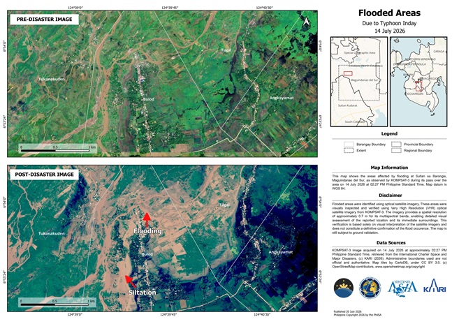
Sample flooded area map (one of six) generated by the Philippine Space Agency (PhilSA) using very high-resolution KOMPSAT-3 satellite imagery captured on July 14, 2026. The map highlights flooded areas in parts of Cotabato and Maguindanao del Sur following the enhanced Southwest Monsoon (Habagat) due to Typhoon Inday. Additional very high-resolution flood maps are available here: https://tinyurl.com/Flood-20260714-KOMPSAT.
The Philippine Space Agency (PhilSA) has deployed advanced satellite technologies to assess flooding and landslide impacts caused by the enhanced Southwest Monsoon (Habagat) triggered by Typhoon Inday, providing critical geospatial information to disaster response agencies.
Using very high-resolution (VHR) satellite imagery, PhilSA generated flood maps for Cotabato and Maguindanao del Sur from Korea Aerospace Research Institute’s KOMPSAT-3 satellite, which offers 0.7-meter spatial resolution for detailed visual assessment. The agency also produced a landslide map for Barangay Ngingir in Calanogas, Lanao del Sur using Pléiades Neo optical imagery from Airbus. All assessments remain subject to ground validation.
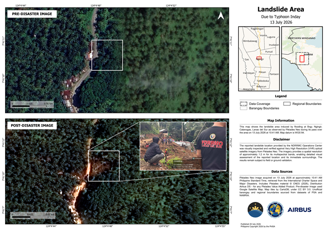
High-resolution landslide map generated by the Philippine Space Agency (PhilSA) using Pléiades Neo satellite imagery captured on July 13, 2026. The map shows the reported landslide area in Barangay Ngingir, Calanogas, Lanao del Sur and supports disaster assessment and response efforts. The high-resolution copy can be downloaded here: https://tinyurl.com/Landslide-20260713-PNEO.
To monitor wider flood impacts, PhilSA utilized Synthetic Aperture Radar (SAR) imagery from the Indian Space Research Organisation’s EOS-4 satellite to map flood extents across CALABARZON and MIMAROPA. Similar SAR analysis using Canada’s RCM-1 satellite was conducted for affected areas in Mindanao.
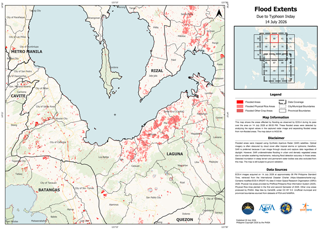
Sample flood extent map (one of 21) generated by the Philippine Space Agency (PhilSA) using EOS-4 Synthetic Aperture Radar (SAR) satellite imagery from the Indian Space Research Organisation (ISRO). The map shows flood-affected areas across CALABARZON and MIMAROPA following the enhanced Southwest Monsoon (Habagat). The complete set of available flood extent maps can be accessed here: https://tinyurl.com/Flood-20260714-EOS4.
Unlike optical satellites, SAR technology can capture imagery through cloud cover and during both day and night, making it particularly effective for disaster monitoring during severe weather. However, PhilSA noted that SAR may underestimate flooding in densely built-up or heavily vegetated areas due to signal interference.
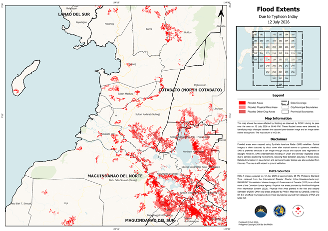
Sample flood extent map (one of 43) generated by the Philippine Space Agency (PhilSA) using RCM-1 Synthetic Aperture Radar (SAR) satellite imagery from the Canadian Space Agency. The map illustrates flood-affected areas across Mindanao based on data acquired on July 12, 2026. The complete set of available flood extent maps can be accessed here: https://tinyurl.com/Flood-20260712-RCM.
The satellite-based assessments were made possible through international collaborations involving space agencies and organizations from Korea, France, India, Canada, Europe, Japan, and the Asian Disaster Reduction Center under initiatives such as Sentinel Asia, the International Charter: Space and Major Disasters, and the Copernicus Capacity Support Action Programme for the Philippines (CopPhil).
PhilSA said the satellite analyses support the National Disaster Risk Reduction and Management Council (NDRRMC) in identifying priority areas for emergency response, demonstrating how space technology and international data sharing can strengthen disaster risk reduction and improve decision-making during natural disasters.